Dynamics and Remote Sensing
The group's work is concerned with composition, transport and dynamics in the atmosphere from the ground to the lower stratosphere. This region of the atmosphere is the subject of current environmental concerns as man-made trace gases perturb the natural chemical and radiative balance. The group's work concerns both measurements and theoretical interpretation, and is based on a range of experimental facilities available at Manchester and elsewhere throughout the world. There is close interaction with other aspects of the Atmospheric Science research in SEAES.
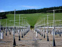
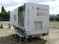
The Mesosphere-Stratosphere-Troposphere (MST) VHF radar is a UK national facility located near Aberystwyth, mid-Wales. This impressive phased-array radar with 400 antennae is used to study winds, atmospheric gravity waves and turbulence from near the Earth's surface to an altitude of 90 km. The site is also the home base of the FGAM UHF 1290 MHz radar which measures winds in the lowest 3 km, and which is mounted on a trailer for easy transport to other locations for field campaigns. Currently, the two radars are being used to study the properties of inertia-gravity waves in the lower stratosphere, the occurrence of extreme winds in the lower troposphere, and the diurnal growth and decay of the planetary boundary layer.
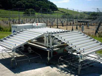
Co-located with the MST radar is a similar facility, but using light rather than radio waves. These laser radars, or lidars, measures the distribution of water vapour, ozone and aerosols in the troposphere and lower stratosphere. This lidar facility is the only one of its type in the UK, and, because of the excellent vertical resolution offered by the lidar technique it provides a uniquely powerful tool for studying transport and dynamics in the atmosphere. Together, the lidar and radar provide information on the generation of turbulence in the atmosphere - both by gravity waves in the stratosphere and by jet streams in the upper troposphere. More information on turbulence gives a better understanding of mixing processes in the atmosphere, and is of direct relevance to the clear-air turbulence encountered by high-flying aircraft.
The lidar is also used for measurements of boundary-layer aerosol, using Raman scattering from atmospheric nitrogen to measure aerosol extinction directly. We have also recently obtained a mobile five-wavelength lidar for boundary layer ozone and aerosol profiling, which is used in conjunction with the boundary-layer wind profiler.
Long-term monitoring of the thickness of the ozone layer is conducted with a zenith-sky diode-array SAOZ spectrometer. With the thinning of the ozone layer currently occurring below 20 km, these measurements are of great environmental importance. We also operate a radiosonde RS90-AG system for measuring temperature, humidity, pressure and wind speed from small balloon packages.
Recent campaigns in which the group has participated include the Emerald 1 and 2 and ACTIVE campaigns to study cirrus clouds and tropical convection in Australia; the NAMBLEX campaign at Mace Head, Ireland, to study the chemical composition of clean oceanic air masses; the TORCH campaign to study the London pollution plume; the CSIP campaign to study the initiation of convection; and the ABWEX campaign to study wind conditions above the BL.
Major awards for the research programme have been provided by the Natural Environment Research Council, the Higher Education Funding Council for England and the EU. The mobile profiling equipment referred to above form part of the NCAS Facility for Ground-based Atmospheric Measurement.